Longitude and latitude are used in daily lives. All around the world, I bet that some person right now is using it, unaware
of what's going on behind the scenes. GPS, as we all know it, pinpoints your location and directs you to your desired
destination. Through this website, I want to let you know the amazing world behind the screens on GPS' and how they work.
Latitude, or the imaginary lines running left to right on the earth complete an entire rotation around.
These lines run parallel to the equator. The Equator is located at 0 latitude, located at the center between
the north and south poles. Lines of latitude are numbered from 0 degrees at the equator to 90 degrees at the north
and south poles. Every line of latitude, except for the equator, must be numbered either N or S (North or south)
to show if the area is north to the center of earth or south of it. Beside the equator, there are four other
lines that run parallel to the equator with special names: Tropic of Cancer, Tropic of Capricorn, Arctic Circle, and Antarctic
circle.


Longitude are imaginary lines that run from the north to south poles. They are also called the lines of Meridian.
The approximate distance of each line is around 12416 miles, or 19981.62 kilometers. Each line of longitude are only
half a circle, because each line only runs half of the earth's circumference. To be clear, there are no real differences
between one line and another, the line of longitude chosen as 0 degrees runs through Greenwich, England. This is the
western hemisphere. Prime Meridian and its opposite line of longitude make up the Great Circle that divides the earth into
the EASTERN and WESTERN Hemispheres. Going from EAST from the Prime Meridian, the lines of longitude are numbered up to 180 degrees.
Similarily, going WEST from the Prime Meridian, the lines of longitude ALSO add up to 180 degrees.


This is very important. Coordinates are very precise and can narrow down to only a square meter away from the target.
For example, coordinates can be 19.89 (degrees) N, 89.76 (degrees) E. This statement suggests that the coordinates leads
to somewhere 19.89 degrees above the Northern Hemisphere and 89.76 degrees to the Eastern Hemisphere.
The first step is to find the coordinates for your location. In this example, I'm going to use the coordinates of
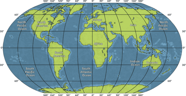
30.58 degrees North, 36.23 degrees East. First we pull up a map that shows the Prime meridian and Equator thus
all the Longitude and Latitude lines like this:

First we corner the North. The Northern Hemisphere is above the Equator, in the following image, then find the closest marked
degree to 30.58. We notice that by coincidence, this location is right above the marked line 30 degrees. For now, we leave a mark
that shows us what height our location is. Next, we find the East. The east region, as we see, is 36.36 degrees. It is to the right of
the closest measurement, 30 degrees E. The final step is to create a line running top to bottom for longitude and a line running
left to right for latitude. The result is where the 2 lines intersect, that is the coordinate location.


